Player-Facing Pointcrawl: Regional Sandbox

Introduction
Pointcrawl versus Hexcrawl Discourse has been heating up lately, and so I've found myself compelled to return to one of my most popular concepts: The Player-Facing Pointcrawl. My friend (and sometimes Warden) Yochai recently wrote a blog post about his experience running a Pointcrawl West Marches that I hope has helped expand some viewpoints regarding how a Pointcrawl framework doesn't have to be restricted to pre-planned content and routes. I highly recommend the read if you haven't already perused it.
However, what I want to focus on today, Gentle Reader, is how to design a Player-Facing Pointcrawl at the Regional Sandbox scale. I first discussed this methodology being applied at a smaller scale, but with this post I want to
- Demonstrate how the method can be used to produce something akin to a regional hexcrawl.
- How to make a Player-Facing Pointcrawl from scratch instead of converting an existing map.
I am providing links to my previous posts on this subject for those who are curious yet unfamiliar, but this post is meant to stand alone.
Player-Facing Pointcrawl Series (not required reading for this post)
- What Makes a Good Player-Facing Pointcrawl
- Cairn in the Classroom (play report of the sessions where I tested the method).
- Player Facing Pointcrawl: Theory and Practice
Method Recap
A Pointcrawl is primarily composed of Points of Interest, which represent discrete locations within an area, and the Paths that characters can use to travel between them. This is generally entirely GM-Facing, with players relying on the GM to explain their options to them.
The goal of my methodology is to create a Player-Facing Pointcrawl map that can be handed out at the start of a campaign or upon entering a new region that only shows the Points of Interest and Paths that would be common knowledge within the region. This encourages players making intentional exploration decisions without revealing to them information that their player characters would not be privy to.
Meanwhile, the GM-Facing Pointcrawl has all of the Points of Interest and Paths of a region, but clearly labeled and organized into three different categories of information:
- Landmark or Obvious information, which is common knowledge or readily observed immediately upon entering an area.
- Hidden Information, which is obscured in some way and requires taking the time to interact and/or investigate to uncover.
- Secret Information, which is occluded to the point where uncovering it is often conditional on PCs taking specific actions or having access to specific resources.
This produces a different sort of exploration compared to traditional dungeoncrawling. Players know more about the space initially, but because most of the Region is actually Hidden or Secret, it's a lot like having the map to a dungeon without it detailing its many hidden rooms and passages.
I am designing this Regional Sandbox from scratch so I don't have to shoehorn my ideas into someone else's design. My goal is to create a space complex enough to be the focus of an entire campaign, but not so complex that it becomes unwieldy for the Warden/GM to prep and run at the table. I will use the Cairn Second Edition Warden's Guide (which I helped make and am obviously partial to) for the initial setup, then explain how my Player-Facing procedure can be applied to transform the results into something suitable for your PCs.
The Process
Process Table of Contents:
Step 1: Region and Factions
I know everyone wants me to get to the part where I show you how to start making a map, but I'm not a map-first kinda Designer. Instead, I started with the Setting Seeds chapter of the Warden's Guide, rolling for both the Culture and Resources so I could get a sense of the region.
This is really important when you are doing procedural generation because the "high-level" information about your setting helps you make connections between various Points of Interest and Factions within your Regional Sandbox.
For Culture results I rolled Mercantile and Security. So the people who live here are very focused on trading and the like, but perhaps there are dangerous things about this region that makes safety an overall concern for the people living in the area.
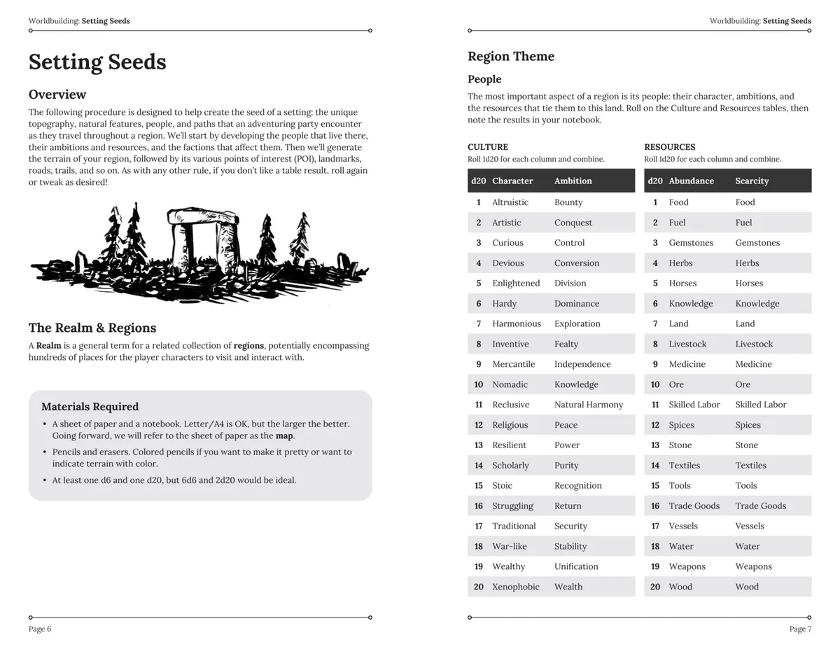
Resources-wise, I rolled an Abundance of Stone and a Scarcity of Food. Now I'm imagining some sort of special stone that is unique to the area, something that Mercantile concerns are trying to extract despite the dangerous nature of the area and issues with feeding the population. We're getting somewhere.
A Sidebar on Procedural Generation: I think procedural generation sometimes gets a bad rap for producing weird, nonsensical results or overly bland content. My general approach is to roll and accept the results, finding a way to make the two disparate concepts gel. If I absolutely can't figure out a way to do that, I reroll one or more of the results. I will also reroll if something is too "on the nose" and doesn't have sufficient conceptual density. Sometimes, I know that one result on a table would be perfect and so I just pick that and roll the other one. Tables are a tool, not a shackle.
Next we tackle Factions. I know it might feel backward to some people to figure out the organizations of a place before figuring out what is actually in the region, but once again knowing these things really helps color the results of your later efforts. I am going to generate 6 Factions because I want a dense Region with a lot of conflicting interests.
Regional Sandbox Factions
Faction 1: Merchants
- Agent: Politician
- Traits: Intellectual and Craven
- Advantages: Alliances and Force
- Agenda: Collect Artifacts
- Obstacle: An internal schism threatens to tear the Faction apart.
Pretty on the nose for a mercantile culture, but the Agent being a politician is interesting to me because it suggests a government that has been co-opted by rich merchants. They are also cowards and yet have Force as one of their Advantages. Perhaps one of their Alliances acts as a security force for their interests. The fact that they Collect Artifacts is starting to change the nature of the Region in my mind. Perhaps the discovery of Artifacts has changed the nature of their efforts to mine the Stone of the Region, and now there are disagreements over what the Faction should focus on.
Faction 2: Artisans
- Agent: Healer
- Traits: Disciplined and Bankrupt
- Advantages: Members (large numbers)
- Agenda: Revive a former power
- Obstacle: Must be done in absolute secret
This practically writes itself. Artisan underclass. Probably used to work the stone of the region in order to enhance its value before export. Want to revolt but have no capital. They are also interested in the Precursor Artifacts, perhaps in order to bring statues they have carved to life, but realize that should they be discovered they will be killed.
Faction 3: Nobles
- Agent: Assassin
- Traits: Pragmatic and Corrupt
- Advantages: Subterfuge, Renown, Beliefs, Magic.
- Agenda: Dominate Others.
- Obstacle: A rare but necessary resource must first be acquired.
Huh. So there is some sort of Noble presence but they work from the shadows. Maybe something happened to where they had to throw their support behind the Merchant Faction, and now they have to bide their time and gather resources before they can regain control of the Region. I'm starting to get the sense that a lot of these Factions are in a race to gather Artifacts that will let them gain the upperhand against their enemies.
Faction 4: Cultists
- Agent: Blacksmith
- Traits: Loyal and Adaptable
- Advantages: Ruthlessness
- Agenda: Infiltrate Another Faction
- Obstacle: Considerable Capital is required.
This will need more time in the oven, but my instinct is to have them want to infiltrate the Merchant Faction because that would certainly require a decent amount of money.
Faction 5: Nomads
- Agent: Merchant
- Traits: Fierce and Collaborative
- Advantages: Charisma
- Agenda: Establish a Colony.
- Obstacle: Another Faction stands in opposition.
Maybe a group of tinkers or nomadic herdsman, looking to establish trade relationships with people in the Region but they will potentially stumble upon things people want kept secret? I'll put a pin in them.
Faction 6: Pilgrims
- Agent: Farmer
- Traits: Judicious and Threatened
- Advantages: Popularity, Alliances, and Beliefs.
- Agenda: Reveal a secret
- Obstacle: Another Faction stands in opposition.
A religious group trying to reveal a secret instead of concealing them? I find that to be an interesting reversal. They have a lot of public Advantages, which suggests that whoever is opposing them is going to have to do so clandestinely.
Blending Region, Culture, and Factions
Okay, big picture with these Factions? Everything suggests that things revolve around some sort of Ancient Artifacts that are powerful but hard to recover/very in demand among the various groups. Perhaps the quarrying of the Stone the region is known for led to the discovery of these artifacts, and now all of the Factions are either competing to obtain them or perhaps fighting to keep others from obtaining them/learning their secrets.
The lack of food means that tensions are going to be high amongst all of the Factions and the normal people of the region: the resources of this region are being pushed past their breaking point, perhaps because the discovery of the Artifacts has inspired a sort of gold rush.
Some groups are powerful and have the means to act openly, and some need to work in secret (and might respond favorably to PCs doing dirty work for them). The most important thing is that PCs will have things to do. They can have been drawn to the region as Artifact Hunters, and there are many Factions that might have need of their services due to cowardness or wanting things done secretly.
Now we need to start setting up our Regional map and figuring out where all of the Factional pieces fit with the Topography and Points of Interest of the region.
Step 2: Topography
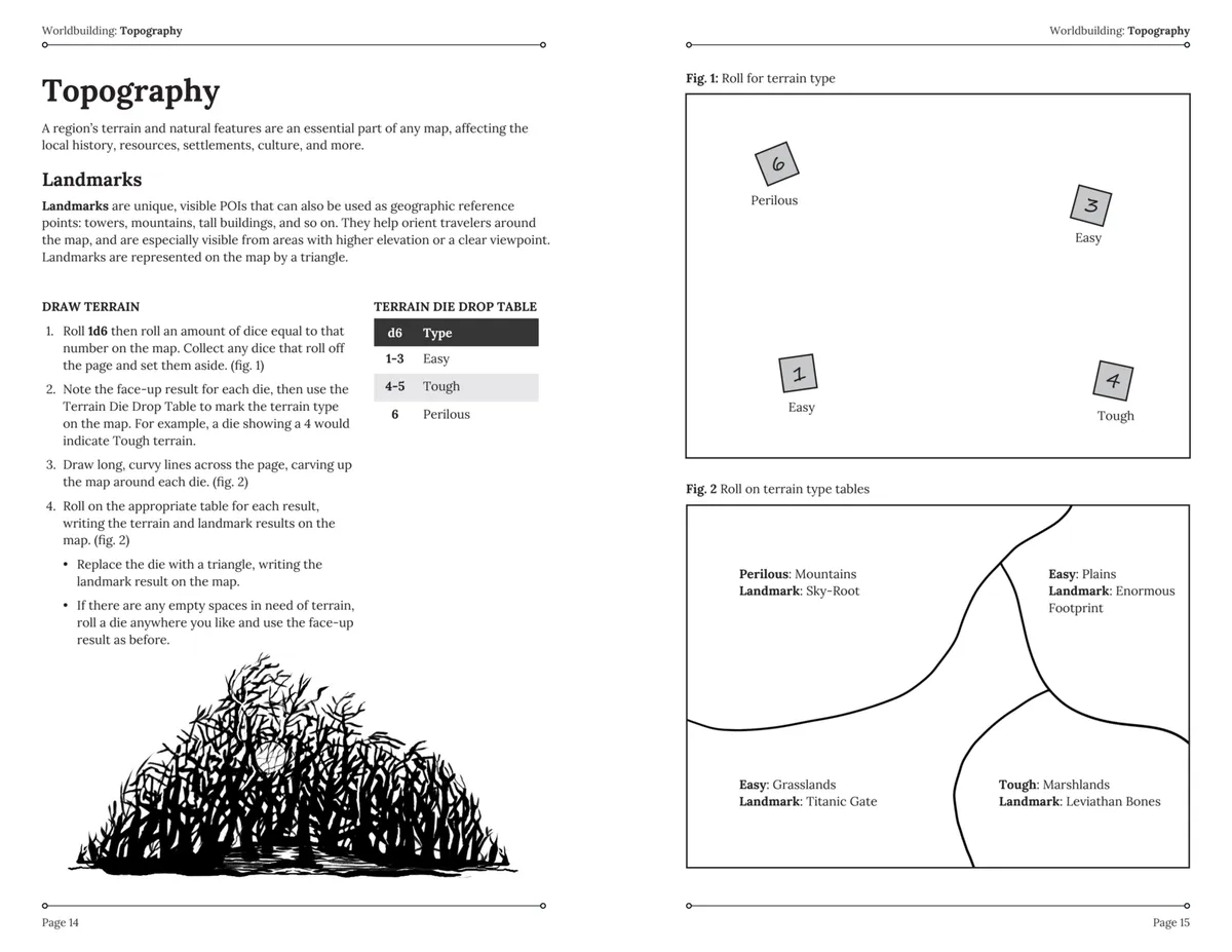
Time to roll some dice and find out what the landscape of our Regional Sandbox is like. I did this with a piece of Letter-sized paper that I later transferred to Excalidraw, but honestly I'd have done an 11x17/A3 if I had had one laying around just to give everything a bit more breathing room. I followed the guidelines under topography, rolling a 4 on a d6 and then 4d6 to determine the type of terrain in the various subregions on the map.
I ended up with 1 area of Easy terrain, two Tough, and one Perilous: this impacts not just aesthetics but also things like how much time it takes to travel through these subregions. Rolling on the relevant Terrain and Landmark tables translated into a subregion of Mountains to the southwest that have a Landmark of Siren Stones, a subregion of Foothills to the south that has a Petrified Forest, a subregion of Canyons to the northwest that has a Sunken Colossus for a landmark, and a Prairies subregion with a Broken Sundial Landmark to the Northeast. I sketched out rough boundaries for each of these subregions that will help me when I'm establishing Paths between Points of Interest later.
Of those regions, it makes the most sense for me that the Prairies subregion would be the most densely populated, so I drew a river descending down through the Mountains subregion, through the Foothills, and passing through the Prairies. I then situated the Heart (or main settlement) of the Region along that river close to the northeastern corner of the map.
Here's what I ended up with.

Regional Sandbox with just Landmarks, Heart, and River. Click image to embiggen.
I went with squares for my Landmarks because it's easier to put text inside them, but the basic principle is the same: They are unique Points of Interest that help orient PCs when they are traveling through a subregion.
I really love the Landmarks that I rolled here because they really support the details I have already established for this Region. Clearly there was some sort of advanced magical civilization here, tapping into the unique properties of the stones in this region. Like many such civilizations in Fantasy literature, they came to a bad end. The Sunken Colossus in the Canyons subregion is an example of their former glory, the Petrified Forest is perhaps ecological fallout from their magic, and the Siren Stones are dangerous magical remnants that defy the understanding of the people who currently live in the region. The Broken Sundial fits the least, but that's okay. It can be a low stakes way of hinting at the deeper history of the region.
Landmarks are great for a Player-Facing map because they are stuff that everyone will mention when they discuss the Region in broad strokes. Everyone who lives in the Heart (main settlement) will be able to tell you that there is a vast Petrified Forest in the Foothills to the south, for instance. This means that even a relatively unexplored subregion will have something of interest compelling curious PCs to explore in that direction.
Step 3: Points of Interest
Time to add the rest of the points! I am rolling 8 d6's, which will produce an equivalent number of Points of Interest (POI), because I want a dense Regional Sandbox to play in. Appropriately, my Mountains subregion ended up with only one other POI, but weirdly so did the subregion that the Heart is located in. The subregion with the most POI density is actually the Foothills, which I quite like because it is the one that touches all of the other subregions.
Take a look.

Map with 8 new Points of Interest established. Click to embiggen.
The really fun thing is how things are starting to fit together. I rolled two more results having to do with Petrified: a Petrified Temple on the border between the Prairie and Foothills and some Petrified Trees with irregular gravity. Speaking of irregular gravity, There is a Floating Fort that hovers over the river (maybe made out of the weird petrified trees with irregular gravity?). There's even a Sunken City with a Buried Library! I'm really getting the sense of ancient magic that got out of hand with this whole region.
If you look at my map, you'll notice that I've made some POI Standard/Obvious, some Hidden, and one even Secret. Standard/Obvious ones will just go on the player-facing map, though not necessarily with Paths clearly indicated. Sometimes this represents things that PCs would be certain to hear about when speaking with others about the region as a whole, and sometimes it's because they just can't miss them. You'll notice, for instance, that I upgraded two POI to Landmark status: The Floating Fort in the Foothills and Purple Geysers in the Canyons subregion that produce isolated weather. This is because, well, there's no way that either of those wouldn't be obvious enough to act as a Landmark. Conversely, I get the sense that the Fortress Integrated With Nature is not common knowledge and so make it Secret. I think maybe it has been in a dormant state since the time of the Ancients, perhaps even longer.
Speaking of Purple Geysers, I decided that they produce strange purple clouds that mostly stay isolated in the Canyons but occasionally produce terrible thunderstorms that sweep through the region. This is why food is is in such short supply: strange violet-colored grasses dominate the Prairie and the only trees in the Region are found Petrified in the Foothills. Food grows poorly and has strange side effects when eaten, so the wealthy import their food. This also gives me the name of the region: The Violet Expanse.
Step 4: Generating Paths
Now, this is the real "Draw the rest of the owl" step. It's why most of you are reading this, I imagine. I wish I could lay out a methodical set of steps to follow, but it is part connecting the dots and part recognizing gaps that need to be filled.
I'm going to start by showing you what the owl looks like after I'm done drawing it, so to speak, but I'll do my best to walk you through how I went from a few circles to a majestic bird of prey.

GM-Facing Regional Sandbox map with Obvious/Landmark, Hidden, and Secret information visible. Click image to embiggen.
I'm primarily asking myself three questions as I decide where Paths need to go. 1. How might the Topography of the region encourage or discourage Paths? 2. What Paths might the previous inhabitants of the region have left behind? 3. What Paths might the current inhabitants of the region use?
These three questions help me decide not only the Paths present, but also whether they are Landmark/Obvious, Hidden, or Secret.
I started by deciding that I needed an old road left over from the previous civilization, mostly because those are awesome and also because I want to subtly encourage PCs to head south into the Foothills because that's where so much of the meat of the Region is. I decide that the Heart is built on an old dock that has a road connecting it that runs all of the way back to the Sunken City in the Foothills. It needs to pass through my Petrified Forest Landmark to do that, and that gives me an idea. I will make a Forestcrawl that PCs must explore and get through in order to easily follow the road to the Sunken City. I'll tie a Conditional Path to the Petrified Trees with irregular gravity as well. Nothing is stopping PCs from deciding to skirt the edge of the forest, of course, but the path of least resistance will require going through.
Now, that road from the Heart is at least 2 Watches until it reaches the Foothills. That means I'm going to be describing it a lot so I need to know a little more. I roll on the Path Features tables and get Abandoned Fields and Gets Extremely Cold. That's really interesting, and helps me reinforce some previous results: The fields are abandoned because the road gets so cold that it seeps into the ground in the surrounding area and kills the crops. Yet another reason the food situation is dire. Why? The Broken Sundial Landmark isn't actually a sundial, it's a magical device designed to detect weather patterns and adjust the road's temperature accordingly. Puzzling this out can potentially be an early win for PCs, but I'll leave a slate tablet on the subject in the Sunken City's library as well.
The trail to the Broken Sundial is along the Road, but overgrown with violet grasses and so not necessarily obvious to most groups, though they can see the sundial, of course. I want to encourage exploration, so in addition to this Hidden Path I'm going to place a Standard Trail leading to the West since there's a gap in the map that could use a POI anyway. I roll a Campground with Distrustful Occupants. This would be a great place to have part of my Artisan Faction, so I put them here to provide a low stakes means of learning about them. If PCs play their cards right, they can use this area as a Waypoint which gives them more options for resting safely.
Most of the time I place Paths between POI, but when they branch off from a main Path it produces a Crossroads decision point, where players can decide to deviate from their original destination. I just mention the opportunities as they start to pass them but make them interrupt me if they want to investigate. Sometimes PCs feel like exploring off the beaten path, and sometimes they want to get something done, and I find that pausing too much and asking for a decision at every opportunity makes some players feel like I want them to go to those other locations and robs them of their sense of exploration.
A Note on Distances: I didn't label distances on the map because it was starting to get a little busy for my liking and I don't want to have to redesign it again for the purposes of an example. In general, using the Cairn Wilderness Exploration procedures, you can assume that most of the Paths are short distance and then modified by Terrain and Path type. A happy accident of POI placement is that most of the Foothills POI are closer together, so the Paths are shorter, but this makes sense given the terrain is worse. There are some Paths that are too short given the terrain they are located in, such as the Trail to the Petrified Temple or Broken Sundial. Generally speaking, I treat uncovering, exploring, and returning from such locations as the use of a single Explore action (see previously mentioned Wilderness Exploration procedure).
The rest of what you see on the map is the result of making logical connections between POI and seeing voids in the map that would benefit from filling. The Sunken City has a trail that leads to the Siren Stones because the civilization of the city is connected in some way to them. There is a means of conveyance to the Floating Fortress from the Sunken City because that would be an obvious requirement. A clever party that discovered the Petrified Trees with Irregular Gravity could also rig up a floating raft to get there, though they would have to show a lot of foresight to not have it be a one-way trip.
I added a lot of POI because something needed to be there from a logical perspective. The Great Hall is Toxic, so it probably isn't frequently visited but is a great place for my Noble Faction. Maybe it is a Hunting Lodge and they spend a lot of their time in the Petrified Forest chasing weird monsters? That means we really need a POI in this region that normal folks actually visit.
Things are probably taken from the forest, and there is likely stone quarrying in the hills, so a Trading Post is a logical POI to have. I roll the second feature and get Illegal Front. I decide this is where my Cult Faction is based out of. Filling a gap to the West I get an Enormous Fist (!) that is the Site of an Ancient Battle. Perfect. This is actually the severed fist of the Sunken Colossus from the Canyons subregion. Seems like a good Cultist ritual site if you ask me. It makes sense that anyone who cares about this Enormous Fist would also care about the Colossus in the Canyons, so I add a Trail connecting them both.
I want a little more going in the Canyons, so I roll another POI for the southern portion and get a Laboratory that is Sealed. I am starting to get the sense that there was an actual conflict here, either a civil war between the Ancients or perhaps their own creations. That makes me want the Ruined Town in the Canyons to be old, and since people have been sniffing around looking for Artifacts that tells me what has happened here: Someone found the Laboratory and tried to break in, and that woke something up that is now operating out of the Ruined Town.
I need to telegraph the threat of this new group, which means the Prairies region needs more going on to the West that this new threat can interact with. I roll for three more POI and get Ruined Town Faction Hideout, Hollow Obelisk that has a Hidden Exit, and a Collapsed Mill with an Abandoned Vessel. This works great. I was wondering why my Artisan Faction would be in something temporary like a Campground, and it is because they were mostly driven out of the Prairie Ruined Town by this ancient threat. No one knows how they are getting into the Prairies subregion because they are using a Secret Path underneath the Hollow Obelisk. Finally, the Abandoned Vessel at the *Collapsed Mill** is a boat that the Artisan Faction uses to smuggle people and goods in and out of the Heart, which means it needs to be connected to the Campgrounds to the east.
The last thing I do is make sure that all of my Factions have at least once place they can be found in the Regional Sandbox. The Merchants are at the Heart, the Artisans at the Ruined Town and Campgrounds, the Nobles are at the Great Hall, the Cultists and the Nomads are at the Trading Post. The only one I don't have sorted are the Pilgrims, so I place a Shrine that is a Pilgrimage Destination near the Siren Stones, close enough to promote religious experiences but not so close all of the visitors wander off into the mountains never to be seen again...
I'm glossing over a few things here due to this section already being overly long, and a lot more can be said about how to encourage exploration of different spaces beyond physical proximity and existing Paths, but I hope this is enough to understand my basic rationale.
Step 5: Making It Player-Facing
This is much easier than the previous step because I already laid the groundwork by figuring out what locations are Standard/Obvious/Landmark, Hidden, and Secret. I simply remove everything Hidden and Secret and I am left with this.

Player-Facing Regional Sandbox map with only Obvious/Landmark information that players would learn without any exploration visible. Click image to embiggen.
The key advantage I see with this approach is it streamlines getting PCs familiar with an area. They will see this map and ask "Hey, what is the Petrified Temple?" and you respond with "Oh, you've heard that is a temple to the local aspect of the Moon Divinity Lūn that was overtaken by a terrible curse of petrification a generation ago." Then, when you are describing them taking the Road south through the Violet Prairie, you can point out when the Petrified Temple becomes visible and the party can decide whether they want to investigate or not.
As players explore the region they will uncover more and more Paths and POI, some through exploring the physical space and others through talking to NPCs, hiring guides, following people, etc. Of course, there's nothing stopping a party from just trailblazing in a random direction on the map, but that is not an activity undertaken lightly given the extra Watches and potential for getting lost that such Wilderness routes incur. This is fitting given that people generally establish routes and stick to them, but the presence of Landmarks does mean that a party has a general direction they can decide to point themselves in if they aren't interested in working with established routes.
Conclusion
So there you have it. One Player-Facing Regional Sandbox map, chock full of adventure to uncover. Of course, it needs a little bit more before it can hit the table. Encounter tables for each subregion, NPCs placed at various POI that are part of Factional schemes, Dungeons and Forestcrawls that need to be developed, etc.
But those are conversational topics for another day.